Photo by Pia Llanquilef Ojed
By Nigel Dennis and Stan Chaladek
On a dark, wet February night in 2001 we landed at Hanga Roa, the only town on Easter Island. After the six hour flight we stepped out into a humid tropical night. Hundreds of crickets could be heard as we scurried across the runway in the pouring rain to the airport building. There were six of us, Frank and Doreen Goodman, Stan and Ema Chladek, Nigel and Joni Dennis.
On our first first day, the North East wind blew like crazy and from our hotel, weobserved lines of swells from the west forming some of the largest surf we had ever seen. We had no idea that this swell would continue to pound the shores of this island for the next two weeks. We rented a couple of rickety Suzuki jeeps and went about exploring, scouting for possible landing spots.
As we explored, we stopped to wonder at the island’s archeological monuments. Most of the island is parched desert crisscrossed by dirt roads, the scouting of the coast was quite easy. Unfortunately it was obvious that there would be next to no landings, so all our skill and experience would be needed if we were to complete the Island circumnavigation.
The Island is roughly triangular in shape; each corner is topped by a dormant volcano, with steep cliffs falling into the sea. Scouting the coast confirmed what we suspected, other than the unprotected Hanga Roa harbor, there were only two places that we could land a kayak in these conditions. Just two small beaches on the north shore of the island: Anakena and neighboring Ovahe Beach.
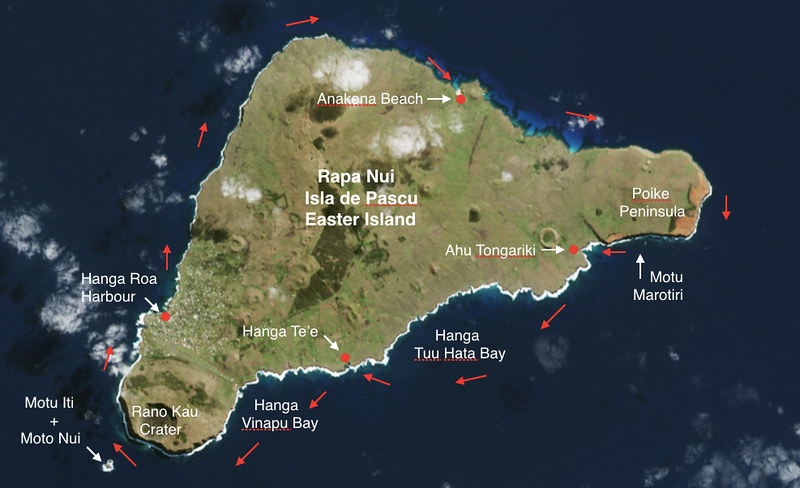
Image of Easter Island from Google Earth
Anakena Beach appeared to be a very good landing, with protection from both western swells and easterly winds. The Ovahe Beach was steep and rather difficult to approach through the reefs, probably not very useful, since it was next to Anakena Beach. The rest of the coast comprised of endless black cliffs, studded with sea caves being bombarded by continuous surf.
The strategy for rounding the island appeared to be fairly simple. Wait for a decent day when the wind wasn’t blowing more that 15 knots. Start in the afternoon from Hanga Roa harbour in a clockwise direction and make it to Anakena Beach. This would offer us shelter and a sandy beach to land on, a good spot for the first night.
We would then hope for a light morning wind, this would enable us to paddle the north shore of the island and round the island’s most committing headland - Poike Peninsula and its exposed Cabo O’Higgins. Local fishermen warned us that the eastern headlands, around Poike Peninsula would have the most difficult rough waters; an area into which they would prefer not to venture. This area had been impossible to scout due its inaccessibility. We were certain that there would be no landings for a good 15 miles.
From there on, it should be all downwind along the eastern shore of the island. We planned for one more overnight stop at either Hanga Hotu Iti or Hanga Tee, both bays had small fisherman landings. The last leg should take us around the last headland Cabo Sur enabling as to reach the “protected” western shore all the way back to Hanga Roa. Upon reaching we should be sheltered from the effect of the easterlies. If we were lucky, we would try to land on a small offshore island, Motu Nui, a tiny speck of land with a mythological significance to Rapa Nui’s ancient inhabitants.
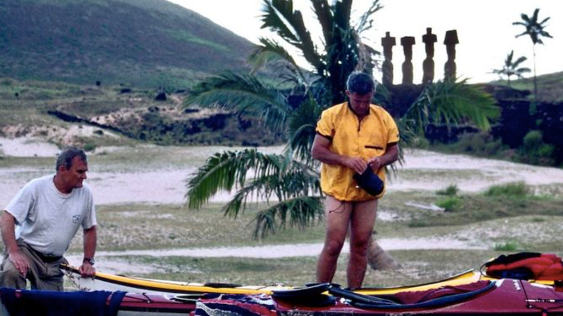
Photo of Stan Chaladek + Nigel Dennis by Frank Goodman
We decided that February 11th was “D” day. It was my birthday and I could think of no better way to celebrate. In the morning, the wind was moderate, so we assembled our sectional fibreglass kayaks, a process which took just about 10 minutes and packed our gear for several days. Frank Goodman had come out with us with the intention of flying his paraglider. He kindly offered to help, so between us we carried the kayaks down to his rented jeep and tied them on the roof.
We had no roof rack, so sleeping pads were used to protect the roof and our tow lines to secure the kayaks. We were all set at about 3pm, so off we went down to the harbor. A few locals gathered and watched. To them it must have been a curious sight. Two of the local youngsters fancied hitching a ride so without invitation they climbed onto the rear deck of both kayaks. We set off out of harbor, breaking through moderate surf, soon loosing our passengers.
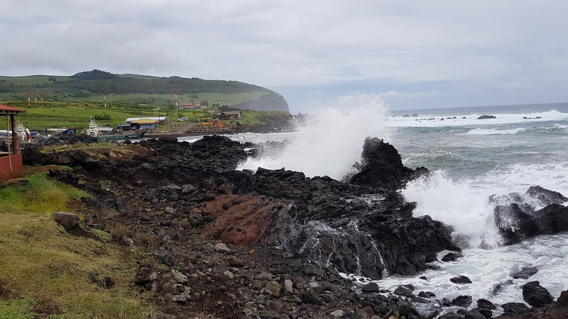
Photo of Hanga Roa Harbout entrance by Marianny Lopes
As we turned northward along the coast, we paddled on through the swells toward the platform of Ahu Tahai, just north of town. Ahu Tahai has a series of statues, some of them furnished with red top-knots, standing on the shore. We were able to recognise the remains of a boat launching ramp, next to a ceremonial platform (Ahu). We paddled along the great cliffs, passing several small islets till we reached the northwestern point of the island where the slopes of Mount Terevaka dissolve in the sea.
As we rounded the headland our compasses swung to a southeasterly direction. We continued along the coast in the shelter of the island cliffs. Suddenly the full brunt of easterly winds hit us, slowing our progress considerably. Soon, large waves were forming and the reality of our challenge became apparent, it felt cold and foreboding. Dark cliffs stretched out before us. As we paddled we passed caves and gullies. Soon we came across a perfect blow hole, a jet of water was pushed out through a small opening in the rock, and a huge fan of water flew high over our heads.
The next three miles were really slow as the head wind had increased. It was now blowing some 25 mph. Finally, as the evening approached we landed at the Anakena Beach through a small surf, accomplishing about 14.5 miles in 4.5 hours. The bay in which the beach is located in is surrounded by a grove of palm trees. It is also the legendary place of the landing of the island’s first king. He arrived from Polynesia some 1,600 years ago.
Near the beach is a large, well preserved Ahu with several standing Moai (statues) gazing solemnly, their large eyes inlaid with coral and obsidian. Around the beach, scattered among palms, are several large toppled statues with empty eye sockets. Some of the large stones used for building the platform were covered with bizarre petroglyphs, showing what is thought to be aku-aku, the protective spirits of the tribe.
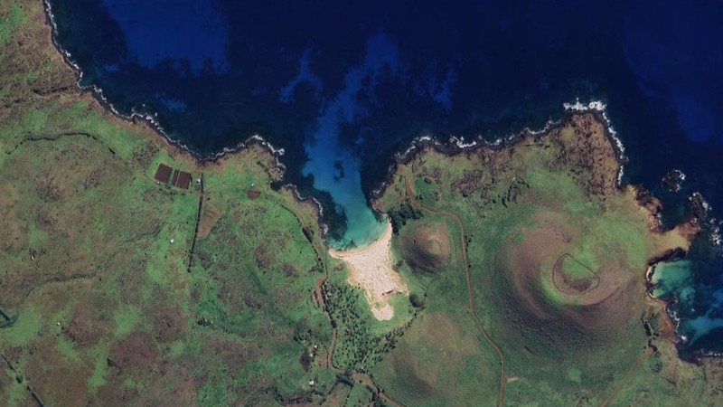
Image of Anakena Beach from Google Earth
As we slept in our bivy bags the wind increased. We were both woken up by the noise of the palm trees and surf crashing on the beach. Too much wind, by 9am it had reached about 40mph. The seas further out were wild, there would be no progress into this wind. The situation did not improve during the day, thus we decided to declare it a rest day and explore on foot instead. Fortunately, if one has to be stuck somewhere, this is the place to be. Good swimming, shade from the sun, protection from the wind and places of interest to explore.
The following morning at 6am the air was still with no trace of yesterday’s wind. We hurried with breakfast and packed the kayaks as quick as possible. Our main problem was that the wind would surely increase as the day warmed. We set off breaking through the surf and paddled at a comfortable pace. The sea was quite jobbly (an unofficial word for rough). About 8am the wind began to increase noticeably. By 9am it was blowing hard straight into our faces. It was incredible, here we were paddling around an island and even when we turned a corner that damned wind was still in our faces.
We could not hear each other over the booming noise of surf and gusting wind, although we were paddling quite a ways offshore. The waves were getting quite large (pretty jobbly), perhaps 15 feet or more, but so far the paddling was not too serious as the waves were not too steep and only once in a while an odd wave would break forcing us into a low brace position.
Progress was fairly slow, but after a while the great headland of Cabo O’Higgins came into view. In about three hours we reached the eastern most point of the island, where the wall of huge breakers forced us to paddle considerable way out to sea. These great white crested lumps must have been formed by the incoming swells meeting the waves rebounding off the cliffs.Although no mention of tidal streams has been made, it was obvious that there was some tidal movement that also affected the wave pattern around this exposed headland. The tide was probably running at 1.5 to 2 knots.
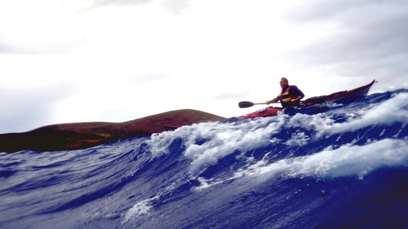
Photo of Stan Chaladek by Nigel Dennis
As we paddled on it was getting harder to keep each other in sight. As the waves got bigger we needed to separate for fear of surfing into each other. Although we tried to stay reasonably close; all we could see was the occasional glimpse of a head, or pitching bow of the kayak on top of a green monster. Eventually the waves were starting to settle and paddling got a bit easier. Finally we turned west toward the bay of Hanga Hotu Iti.
We now had to contend with very confused following seas, which was perhaps the hardest paddling so far. The kayaks were pitching and surfing down the face of waves. Every so often a wave would build up and break on us forcing us to brace while the wave passed. We were coming closer to our next goal. Onwards, past the needle of Mot Marotiri, this great column of rock forms an impressive stack. We had to pass it on the seaward side due to heavy seas.
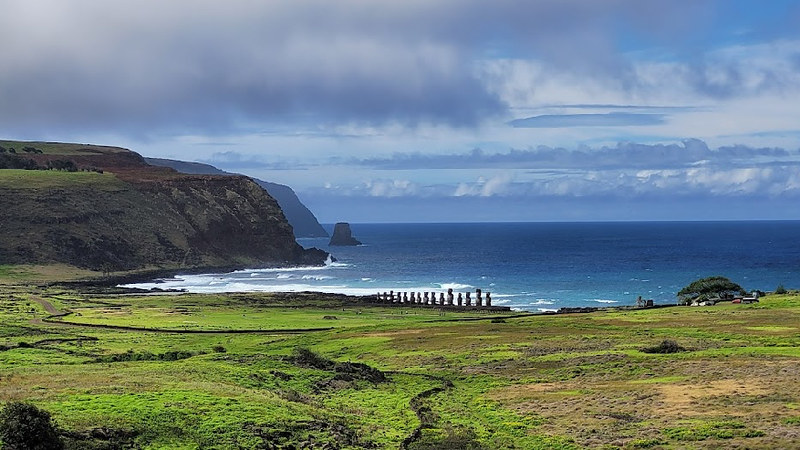
Photo of the needle of Mot Marotiri by Pia Llanquilef Ojed
It did not take long to surf into the bay, but then there was another problem. We knew that there was a little harbour in the corner of the bay and we could see the starboard light that marked the entrance. As we approached, the sea became very confused. If the water remained deep enough we should be able to pick a route into the harbour. Soon we were winding our way between the rocks, now paddling quickly as we had to time our approach between the large swells.
Finally, we found a small rocky nook, protected by a tiny sea wall, where a fishing boat was anchored. The fishing boats of Easter Island are very similar in design to the couraghs, still found on the West coast of Ireland. Yet here we were thousands of miles away and the boats evolved to a similar design. We have to suppose that if you dare to fish in such waters with such a basic craft eventually all hull shapes will evolve to the same design as all will be striving for the most seaworthy of the hulls.
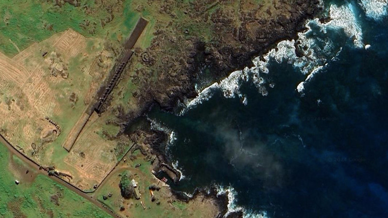
Image of Hanga Tee Harbour and Ahu Platform from Google Earth
We landed next to the great platform of Ahu Tongariki, with a row of Moai, which was toppled by a great tsunami wave in the 70’s and restored shortly after. Again, a row of silent stone sentinels, some with red top-knots, was looking inland, over the coastal plain, where a settlement perhaps once stood. A short way inland the basalt outcrop was carved with a large profusion of enigmatic petroglyphs. Some of them were bird men, more of them were turtles, barracudas and mysterious faces of the cannibal god Maku-Maku.
After a short lunch break we set off on our last leg for the day. We hoped we could reach the bay of Hanga Te'e as this was the only possible protection on this part of coastline. As we set out we were forced to paddle out to sea. We had no choice as the wind was blowing approximately 25-30 mph and that coupled with the swells and underlying reefs gave us difficult sea to contend with.
As we approached the bay of Hanga Tuu Hata the seas kicked up once more. Waves were forming great tubes and exploding over the outer reefs. It was necessary to head still further out to sea, about a mile and half out. Looking towards the land, the coastline could only be seen as we reached the crest of the swells. Most of the time all we could see were the backs of the huge swells together with walls of foam and aerated water as the swells finally collapsed. It took us some 2 hours of paddling before we started to turn toward the shore, looking for the entrance to the bay of Hanga Tee, constricted by huge reefs again.
From a distance of some 2 miles we thought that we were able to recognise the headland. We were evidently on the right track, after a while we recognised Frank Goodman and Stan’s wife Ema standing on the point. By that time we were in big seas again, riding steep breaking waves toward the shore. The entrance turned out to be a fairly narrow channel between black jagged reefs. We will probably never forget the images and apprehension as we approached. It was impossible to tell the exact route in as neither of us could see the channel.
Fortunately for us Frank had positioned himself and was directing us in waving a white handkerchief. Again, steep crested waves crashed around us as we picked our way in through the reefs sending up huge walls of foam. Dark shapes of volcanic rock would appear periodically in the foam. Fortunately all went well and we found the right channel and entered the placid lagoon, where waves gradually diminished to some 6 feet and finally rode to a small niche where the fishing boat wasanchored.
We accomplished some 20 miles this day in some of the roughest conditions that any of us had ever paddled. We camped that night next to a fisherman’s hut and spent part of the evening exploring the ruins of nearby Ahu Hanga Tee with fallen giant statues, petroglyphs and a few red scoria top knots laying around.
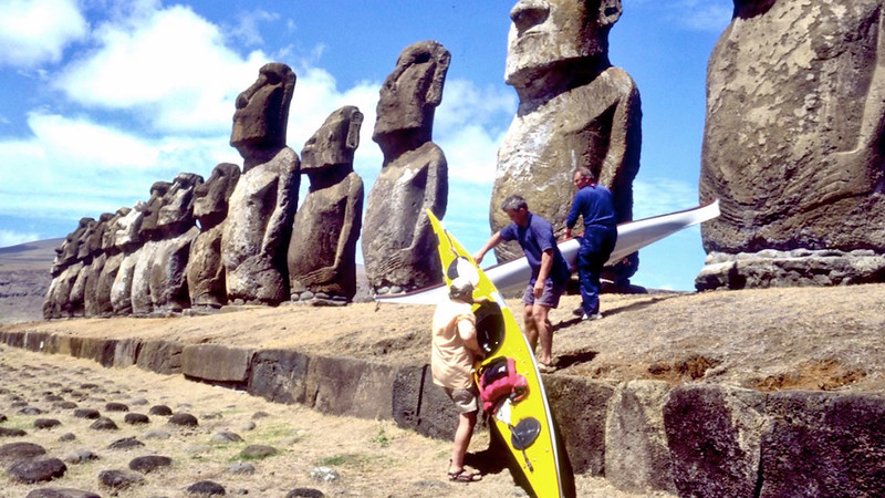
Photo of Frank Goodman, Nigel Dennis and Stan Chaladek by Ema Chladek
The next morning greeted us with a red sunrise as we set out early for the last 17 miles leg of our journey. The swell was bigger than the previous evening, we had to time the breakout through the huge crashing waves in the gap between the reefs. After a few moments of furious paddling we were out and set our course southwest across the large bay of Hanga Vinapu.
As we later found out, at the head of the bay is a small beautiful ruin, the Ahu Vinapu. Its perfect masonry may have lead the Norwegian anthropologist Thor Heyerdal to compare it with the Inca masonry of Peru and speculate on the South American origins of the Rapa Nui stone age culture. The stone idol, standing in the front of this platform looks different from the other island’sstatues and provided fuel to some speculations of its origin.
We paddled on, cranking the miles out across the wide expense of the bay, as long as the beautiful weather would last, there would be nothing to worry about. Once again this was not to be. After about one hour of paddling we noticed the ominous darkening of the sky on the eastern horizon. A storm was approaching quickly; soon the whole sky turned into a deep indigo. The wind would pickup and the sea would start to break. We both knew this, but could not tell how hard it would blow. We could not return into the wind and head seas. Neither did we have the luxury of being able to land.
We had only one choice, to turn directly south and paddle away from land. It was already blowing 25-30 mph, once the wind picked up still further, there would come a point when we would only be able to paddle directly downwind for any length of time. The race was on to get as far out as possible, so we could then turn west and run with the wind behind us. This course would enable us to clear the next headland, Cabo de Sur. If we managed to clear it, we would be able to gain shelter from the high cliffs.
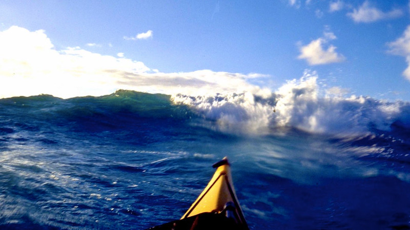
Photo of waves by Nigel Dennis
This was potentially the most dangerous part of the expedition. There was nothing we could but accept the position that we found ourselves in and get on with the job. There was no turning back and only one option. Once you come to terms with this you settle down and a strange sense of acceptance takes over. The sea state changed in no time and suddenly we were in the midst of 25 foot high steep waves, some of their crests were being blown off.
The seas were spectacular, it was quite an interesting sight to see each other surfing the wave faces and pivoting on the wave tops. Although it seemed to be almost insane to be paddling a kayak in these waters with only your blades to rely on, it does prove how seaworthy the kayaks are. Finally we turned and headed west. After a while of constant battling with the angry ocean the islets of Motu Iti and Moto Nui came into view.
As fast as the storm started it was over and we were now passing along the great cliffs of the Rano Kau crater, some 1,000 feet high, straight under the ceremonial village of Orongo. The one hour storm with it’s following seas helped push us quickly along! Big swells were rolling in from the west, and the huge surf, formed spectacular foaming tubes. The off shore wind was creating spectacular water fountains which sped towards the sky as the waves broke into the vertical cliffs.
As we passed Motu Nui it became obvious that landing on the islet would not be possible, swells were wrapping around the small island and plumes of foam were flying above the top of island. We chatted insensibly about how the Bird Men could have coped in these seas and how dangerous their deadly contest was. This chatter was probably the result of the realisation that we had reached relative safety.
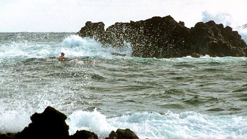
Photo of Nigel Dennis by Frank Goodman
We paddled on in a northerly direction, keeping our distance from the breaking swells. We continued north and soon we were manoeuvring into the open harbour of Hanga Roa. Now all that was left was to surf in through breaking swells and land at the small beach and our trip was over. Moai evidently watched over us and wanted us to come back and tell the tale, so we landed in one piece.
A few days later, we hired a fishing boat and visited the Isle of Itu Nui. It looked like an exceptionally calm day, but the boat still could not land. Somehow we managed to jump onto the small flat spot that stuck out from the island’s cliffs. Even then we could not have landed a kayak. On the island we met the large profusion of rather tame sea birds, unseen on the main island. We also found caves with ancient rock art. It was quite scary to see the Maku-Maku staring at you from the darkness of the cave!
The expedition had finished, it had probably been one of the most demanding rough water trips that either of us has undertaken. Easter Island is only small, but is an island that certainly has a sting in its tail. A very jobbly paddle!
By Nigel Dennis
Nigel completed the first sea kayak circumnavigation of Great Britain in 1980. Since then he has carried out expeditions around the world and owns and runs Sea Kayaking UK and Celtic Paddles.